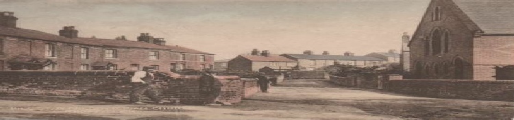
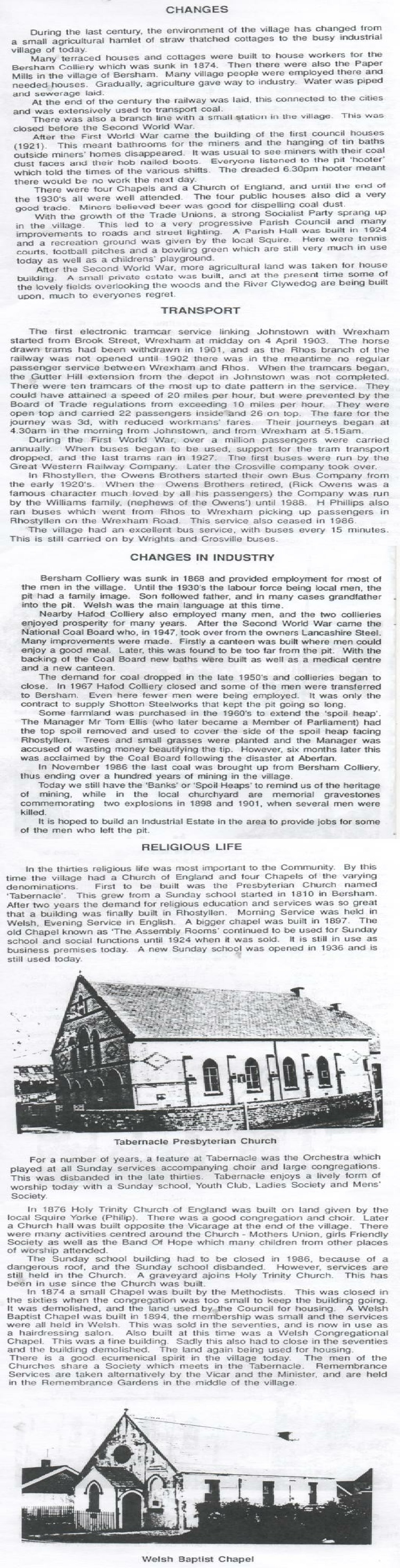
Rhostyllen
A history through pictures

The meaning of the name of Rhostyllen
A N Palmer 1903 -
Wikipedia – “Its name may be derived from the Welsh words rhos meaning ("moor", or "rush pasture" – purple moor grass and rush pastures) and estyll ("staves" or "planks").
'Dictionary of the place-
I came across some old newspaper cuttings which said that “Bersham people often referred to Rhostyllen people as those that live “over the plank”, meaning the wooden footbridge over the River Clwedog!
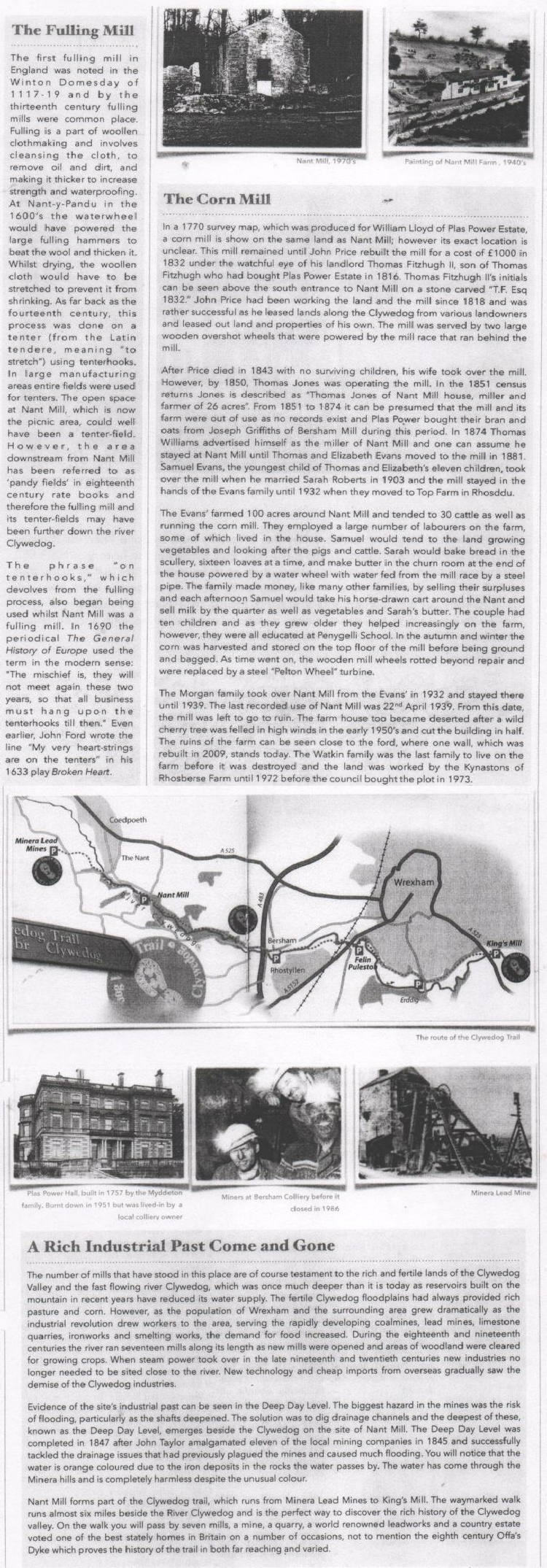
Early Industry
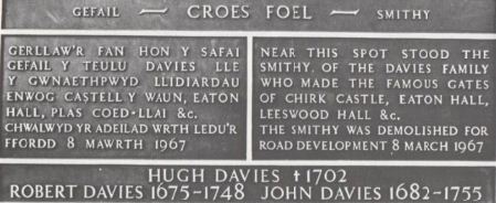
The Davies Family were renouned Blacksmiths at the end of 17th and 18th centuries. They lived at Croes Foel Farm near Rhostyllen and had a smithy alongside the farmhouse
William Davies was the smith at Rhostyllen in the mid 17th century and may well have been the father of Hugh Davies
Hugh Davies originally resided at the Rhostyllen Smithy but some time after 1676 moved to Croes Foel Farm. He is recorded in the Chirk Castle Accounts for 5th August 1690 as having been paid for work at Cadwgan Mill
Ancient History
A N Palmer – in the History of the Thirteen Country Townships of the Old Parish of Wrexham 1903 wrote…….
“The village of Rhostyllen is of quite modern origin and is situated in the Township of Esclusham Below.
Esclusham -
In the great seigniorial surveys of 1315, 1391 and 1445 Esclusham is seen held by members of three kin groups on the rapidly disintegrating system of communal Welsh land tenure based on the gwely and gafael. By 1552 and 1620 this communal element had disappeared. Individual ownership, even small estates were the order of the day. But the very minor gentry families (uchelwyr) still maintained their close ties of kinship.
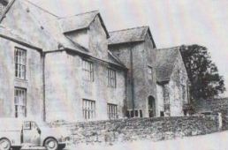
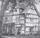
Plas Cadwgan Hall
Families of claimed descent from the 14th century progenie de ken (Cynwrig ap Rhiwallon) were Trafford (Esclus Hall), Jones (Plas Cadwgan), Wynn, Tegid, Jones (Vrondeg), all surviving to adopt surnames English fashion, in place of the Welsh patronymic”.-
Esclus Hall (known as Esless)
Other General Information
Rhostyllen was a part of the old township of Esclusham Below (i.e. "below" Offa's Dyke) and in 1879 was incorporated into the new ecclesiastical parish of Esclusham. The parish church, Holy Trinity, was completed in 1877. The corresponding civil parish of Esclusham became the community of Esclusham in 1974.
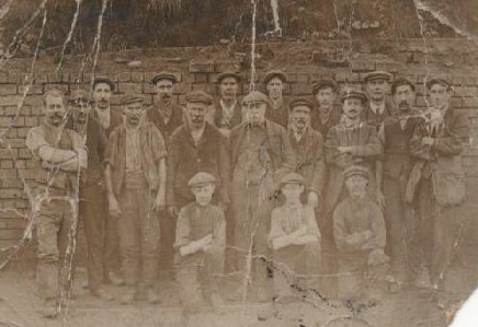
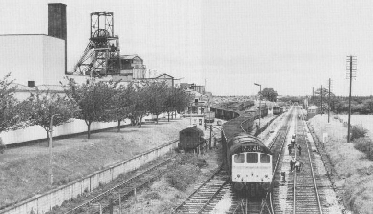
Bersham (or Glanyrafon) Colliery, was sunk by Mr Barnes of Liverpool in 1864 and before its closure in December 1986 was the last working coal mine in the Denbighshire coalfield, situated to the east of Wrexham Road, Rhostyllen. The worst disaster in this pit occurred in 1880 when 9 men lost their lives (including the manager). A memorial to these men can be found in Rhostyllen Church.
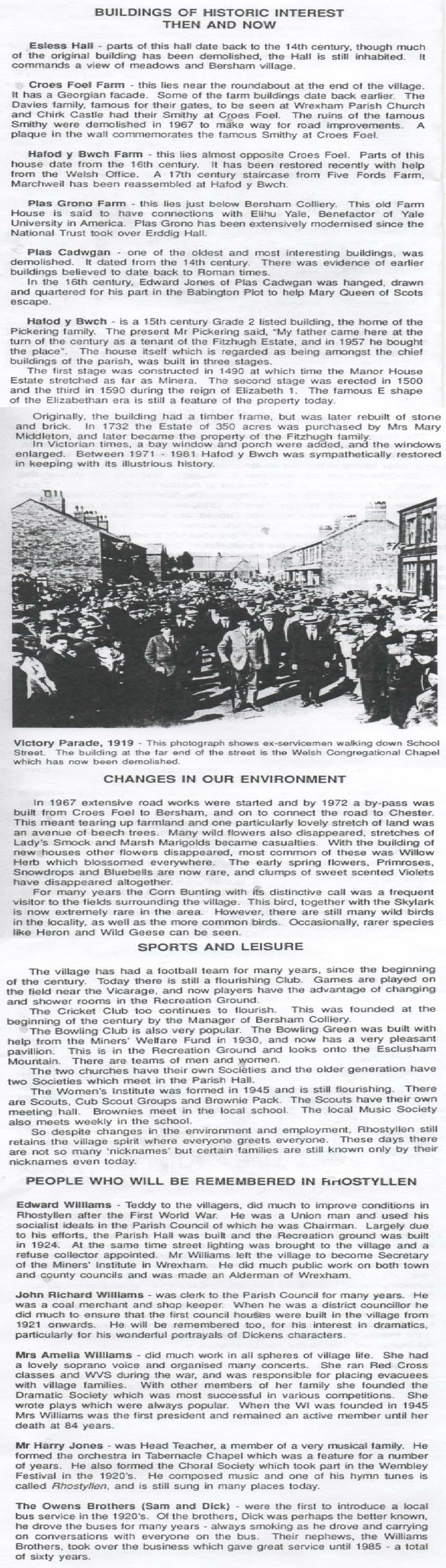
1920’s (early) Bersham Colliery Miners
Like other villages in the area, many of its buildings are nineteenth-
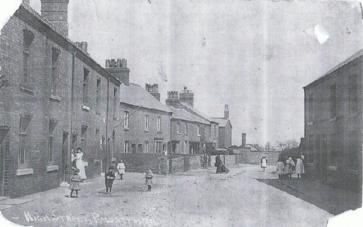
1909 -
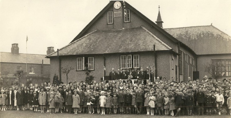
The focal point of the village is the village hall, built in 1924, and its recreation grounds. Pictured below in circa 1938
The railway station closed to regular passenger trains on 1st January 1931 and excursions in the mid 1950’s while freight trains continued to pass through on their way to Rhos until October 1963. Rhostyllen was a minor railway station of the Great Western Railway, located on the Rhos Branch just off the Shrewsbury to Chester Line a couple of miles south of Wrexham. Rhostyllen was a mining area and the rail-
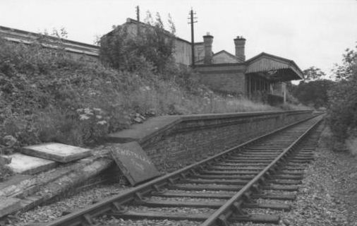
Rhostyllen Railway Station with the Foundry in the background.
From studying the Business Directories it became apparent that there was an iron foundry in the “Village” in 1892. At this point in time it was owned by Mr Thomas Davies of Rhostyllen. Some of the grid covers manufactured here can still be seen in the Wrexham area.
1972 -
The village was also formerly served by the line of the Wrexham and District Electric Tramway Company, opened in 1903, which ran from Penybryn in Wrexham to Johnstown and Rhosllanerchrugog: the halfway passing loop was situated at the Black Lion inn
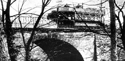
Tram over Felin Puleston Bridge
Rhostyllen -
This informative booklet was published in 1992 by Rebecca Angus. The first part of it is featured in the ‘Memories’ section of this website. I would have loved to have met this lady because she obviously wanted the history of the “Village” to be preserved for all to see (just as I do). Well Rebecca your work is now on the world wide web. Recognition at last!
For much more information on Religious buildings and establishments please click into the Buildings and Street Scenes section of the website
For more information on Education in the villages of Rhostyllen and Bersham please click into the Rhostyllen School and Bersham sections of the website.

General History
(Source A N Palmer written in 1903)
“The modern village of Rhostyllen has grown up between two ancient farmsteads” The first of these was called “The Rhos Farm” which belonged to the Chirk Castle Estate (The Myddeltons of Chirk Castle had much land belonging to them in Esclusham Above and Below) and was occupied for generations by a family named “Griffiths” and remained until lately, although divided into cottages. You pass the place where it stood in traversing the footpath from the modern village of Rhostyllen to the Ddol in Bersham.”
This farm was situated between the Swan Inn and the forty six steps on the way to Bersham. It is shown on a map dating from 1829
“The other farmhouse also belonged to Chirk Castle, and occupied the site of the present Esclusham Vicarage. The farm was called “Bryn y pentre” (Hill of the hamlet”). In 1647 this farm belonged to Gerard Styles, gentleman. Some of the old farm outbuildings still remain”
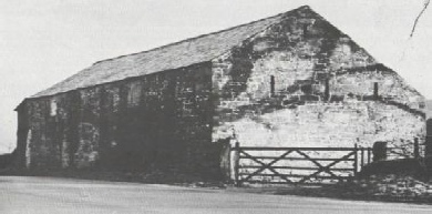
Was one of these outbuildings that A N Palmer referred to in 1903, what was locally known as the “stables” or “tithe barn”? “This tithe barn was used to store produce from the Rhostyllen area and was built in 1623 by E Wyatt it was situated between Rhostyllen Parish Hall and the Vicarage”
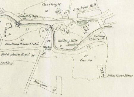
1829 -
I came across a map of Bersham, which also showed a part of Rhostyllen, dating from 1829 and could find reference to only three named places situated where the village of Rhostyllen is now. They were:
Rhos Farm – which I have already mentioned
Erw Garn -
Cae Du -
Erw Garn and Cae Du were situated on land owned at the time by William Farr of Bryntirion Hall
Bryntirion Hall is also close to the site of the Hill of the Hamlet farm (where the Vicarage is now)
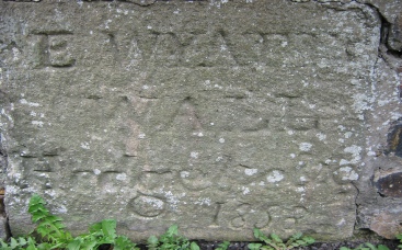
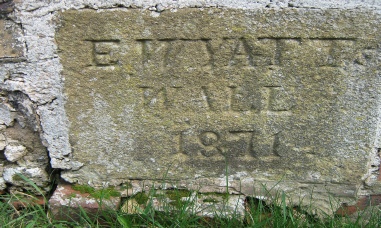
As you turn into the Parish Hall car park on the way to the bowling green, on your right there is an old wall between the Parish Hall and the old age pensioners bungalows (where Pleasant Terrace, Chapel Street used to stand). Within this wall there are two stones with the inscription E Wyatt 1858 and “Hedgelove” 1871.
- Could this old wall have been part of the boundary of the “Hill of the hamlet” farm (circa 1600’s) which stood on the site where the vicarage is now?
- Could the wall have served as a boundary for Bryntirion Hall?
- Or could the two aforementioned stones have been reclaimed from another place and built into the wall?
What we do know is that an Edwin Wyatt (Solicitor) lived at Bryntirion Hall and owned some of the land which is now known as Rhostyllen. He died in 1876 and much of his estate was sold off and subsequently became Rhostyllen as it is today (especially the upper part of the village). His nephew and heir (Major Charles Edwin Wyatt) appears on land sale deeds from circa late 1870’s for the area now known as Hill Street and Poplar Road.
We will probably never know the significance of the wall or the meaning of the two stones? But it is interesting to speculate!!!
Hill of the
Hamlet Farm
Rhos Farm
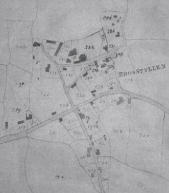
1844 Tithe Map
Church Street
Hill Street
Old Black Horse
The Swan
Old Vicarage
Tithe barn
The following documents have been published by Wrexham County Borough Council (previously Wrexham Maelor Borough Council) who have and continue to do much to preserve and document local history and should be commended for their work
Esclusham by Raymond Lloyd
Many thanks go to Ian Lloyd for sharing his Father’s collection with me.